Peize Formation

Code
NUPZ
Status
Formal (Bosch 2003).
Lithological description

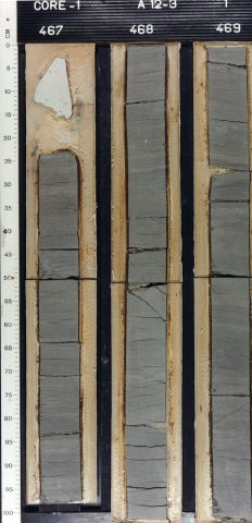
Light grey to white fine to very coarse sand, fining westward, non-calcareous, slightly to moderately gravelly (quartz dominant). Locally at the top, sand layers with angular cobbles. Subordinate clay beds (abundant in the Balk member) without marine shells. Regionally, light grey very fine to fine sand at the base.

Depositional setting

Fluvial (Eridanos, Baltic River System), shallow-marine (delta front; very fine to fine sand at base), coastal and river plain (delta top; sand with clay layers).

Definition of lower boundary

Commonly marked by clay layers (Balk Member). Sharp contact with glauconitic, commonly shelly, shallow-marine fine sand (Breda Formation). Gradual transition (where base is fine) into or sharp contact with finer and more calcareous shallow-marine sand (Oosterhout and Maassluis Formations). Gradual transition into non-calcareous, micaceous and brown fluvial sand and clay (Waalre Formation).

Definition of upper boundary

Locally marked by a unit with cobbles (Hattem Layers, cf. Zandstra 1971). Commonly, gradual transition into multi-coloured, calcareous fluvial sand and gravel (a.o. lydite and milky quartz; Appelscha, Sterksel and Urk Formations), or into fluvial sand and clay (Waalre Formation).
Thickness indication
Up to about 180 m.
Geographical distribution
Southward, commonly indistinct transition into interfingering fluvial sand and clay (Waalre Formation).
Regional correlation
IJmuiden Ground and Yarmouth Roads Formations, defined and mapped in conjunction with the British Geological Survey (Long et al. 1988); UK: not present; GER: upper part of the Kaolin Sand (Stephan 2014); BEL: not present.
Age
late Pliocene - early Pleistocene.
Holostratotype
Depth (thickness) AH:
80 - 162 m (82 m) below land surface
Parastratotype
Depth (thickness) AH:
107.2 - 237.5 m (130.3 m) below land surface
Parastratotype
Depth (thickness) AH:
86 - 264 m (178 m) below land surface
Origin of name
Named after the village of Peize in the northeastern Netherlands.
Previous name(s)
Harderwijk Formation, lower part of Enschede Formation and a large part of Scheemda Formation (cf. Doppert et al. 1975), including the Weerselo Deposits (cf. Van den Berg & Gaemers 1993). Hattem Layers (with cobbles).
Reviewed by (date)
Wim Dubelaar (2018), Sytze van Heteren (2019).
References
Bosch, J.H.A. 2003. Beschrijving lithostratigrafische eenheid. Nederlands Instituut voor Toegepaste Geowetenschappen TNO. Utrecht.
Doppert, J.W.Chr., Ruegg, G.H.J., Van Staalduinen, C.J., Zagwijn, W.H., Zandstra, J.G. 1975. Formaties van het Kwartair en Boven-Tertiair in Nederland. In: Zagwijn, W.H., Van Staalduinen, C.J. (eds.): Toelichting bij geologische overzichtskaarten van Nederland. Rijks Geologische Dienst, Haarlem, 11-56.
Long, D., Laban, C., Streif, H., Cameron, T.D.J., Schüttenhelm, R.T.E. 1988. The sedimentary record of climatic variation in the southern North Sea. Philosophical Transactions of the Royal Society London B, 318 (1191), 523-537.
Stephan, H.J. 2014. Climato-stratigraphic subdivision of the Pleistocene in Schleswig-Holstein, Germany and adjoining areas: Status and problems. E & G Quaternary Science Journal, 63(1), 3-18.
Van den Berg, M.W., Gaemers, P. 1993. Tertiair. In: Van den Berg, M.W., Den Otter, C. (eds.): Toelichtingen bij de Geologische kaart van Nederland 1:50.000. Blad Almelo Oost/Denekamp (28O/29). Rijks Geologische Dienst, Haarlem.
Zandstra, J.G. 1971. Geologisch onderzoek in de stuwwal van de oostelijke Veluwe bij Hattem en Wapenveld. Mededelingen Rijks Geologische Dienst, Nieuwe Serie 22, 215-259.
Cite as
TNO-GDN ([YEAR]). Peize Formation. In: Stratigraphic Nomenclature of the Netherlands, TNO – Geological Survey of the Netherlands. Accessed on [DATE] from http://acc.dinoloket.nl/en/stratigraphic-nomenclature/peize-formation.